 The City of Tucker has weathered a multitude of changes throughout its lifespan. Its community has a long and storied history stretching back from at least two centuries to its present in 2022, and lifelong residents can speak to the evolution the area has endured. Many of its changes have come recently as the privileges of cityhood make it easier to undertake ventures to improve traffic, support local business, and maintain our parks and greenspaces. With so much recent growth, it is vital that the City has a way to keep track not only through articles and written records, but also visually.
The City of Tucker Geographical Information Systems, or GIS, Department is responsible for the creation and upkeep of the official City of Tucker map and other online applications. These include programs showing the hours and services of restaurants around the City, identifying local recreation centers and parks, and locating bus stops and other important infrastructure in Tucker. These applications make it simple for residents to stay up-to-date with what relevant changes have occurred as well as what those changes look like.
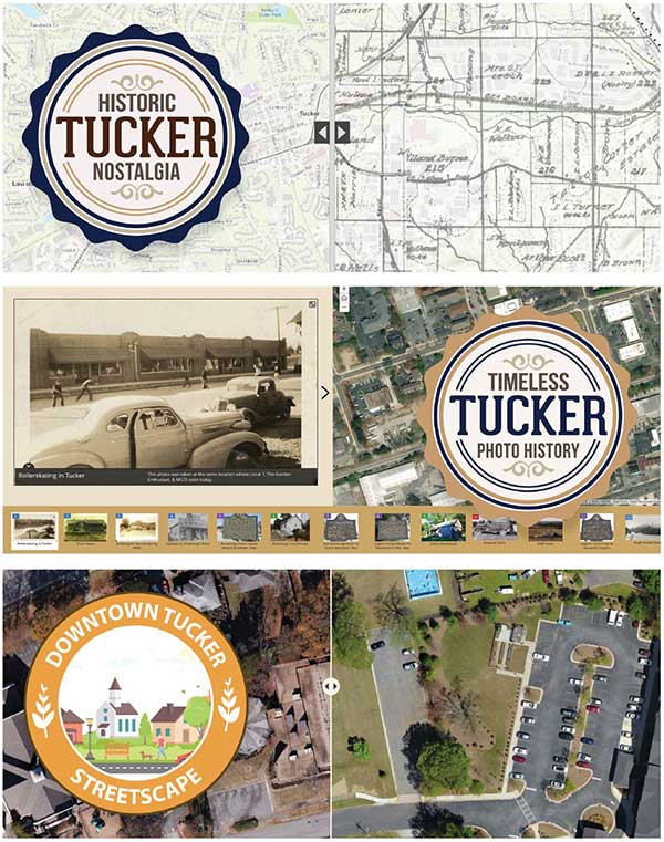
GIS’s influence does not end with these conveniences. A few specialized map applications have been created not only to show the City as it is now, but also to relate the Tucker of the distant past.
In 2017 the City of Tucker GIS Department unveiled the Tucker Nostalgia application to directly compare modern Tucker to the Tucker times gone by. The app utilizes a draggable bar with the newer City features on the left and a 1915 DeKalb County map overlaid on the right. Provided by the Tucker Historical Society, the map shows the railroads, power lines, and other prominent features of 1915 Tucker. Users may move the bar to see where these historical features would be located today.
In 2018 came the creation of Timeless Tucker, another GIS-made app featuring photographs offering a glimpse back into 126 years of Tucker history. Locations are marked on a modern-day map of the City and clicking on them shows photographs taken in the past in that very same location. In addition to supplying the photographs themselves, the Tucker Historical Society has included short descriptions detailing the context in which they were taken.
Now, in 2022, GIS has created a map showing more recent developments in downtown Tucker. Using the same draggable bar as in the Tucker Nostalgia app, users may compare 2017 downtown on the left to its current configuration on the right in the Downtown Tucker Streetscape web app. From the demolition of the old library to the in-progress creation of the Trail segment, a lot of progress has been made in a comparatively short amount of time.
Using maps like these helps us to remember Tucker’s past as well as plan for its future. As projects are taken to improve the City, keeping historical context in mind helps to ensure that Tucker keeps the classic parts that make the community what it is today. In looking at these relics of the past, the City also looks forward to the years to come.